 |
 |
|
We ship what we sell, no expensive 3rd party shipping. |
|||||
|
By Bidding in this sale you are
agreeing to the Terms of Sale.
Click Here to read the Terms of Sale.
|
|||||
| This Auction is Now OPEN for Bidding Closing LIVE ONLINE: SATURDAY • March 30th • Starting at 9:00 AM Pacific Time |
|||||
| Absentee Bidding on a Specific Lot Will Remain OPEN Until the LIVE BIDDING begins for that Specific Lot on SATURDAY • March 30th |
|||||
A 25% Buyer's Premium Will Be Added To The Price of Each Lot in Your Invoice |
|||||
Table of Contents > Civil War Era > Lot 205 |
|||||
|
Browse the Auction in Groups of 25 Lots: |
|||||
Lot Number: 205
Click for a Printable PageSign-in to Bid or Register to Bid Estimate Range: $800 - $1,200 |
|
||||
1876 Extremely Rare First Edition Printing of a Report On U.S.S. Intrepid Torpedo Fittings and for Other Navy Vessels |
|||||
       Click an Image to Enlarge It |
|||||
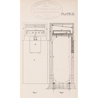
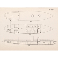
1876, Extremely Rare First Edition Printing, “Suggestions On Torpedo Outfits Of The Vessels Of The Navy” and “Report on the Torpedo Fittings of the U.S.S. Intrepid,” by Lt. R. B. Bradford, Complete, Choice Very Fine. An important original First Edition Printing of this 19th Century 1876 Centennial Naval report treatise, contains 24 pages of text, plus Four Full-page Plates. This violet soft cover booklet measures 9" x 5.75”. It was published by the United States Navy Bureau of Ordnance, and printed by the Government Printing Office (GPO), in Washington, DC.In 1874 Lt. Bradford performed an experimental fitting of torpedoes on the newly built U.S.S Intrepid at Newport, Rhode Island. His report on this project is dated February 1, 1875. Afterwards he considered the fitting of torpedoes on other U.S. Navy warships, and wrote his second report dated February 1, 1876. These two reports make up this current treatise. This is a scarce early American Naval publication on the subject of movable torpedoes. The steam-powered U.S.S. Intrepid was built in 1874 as an Experimental Torpedo Ram Ship, being the First U.S. Navy Warship to be armed with self-propelled torpedoes. The torpedo design incorporated in this historic vessel greatly influenced the future course of submarine warfare. So new was the actual incorporated use of electricity on naval vessels at that time, that Bradford states: “Not a single mechanic or person of any kind from the Torpedo Station went on board of the “Intrepid” to do any work concerning these fittings excepting myself. The absence of skilled workmen accustomed to deal with electricity rendered it necessary, however, for me to do considerable mechanical and manual labor.” We have not been able to find another copy of this early work offered for sale anywhere to date. Internally this book is in Extremely Fine condition, with very light tone having with no tears or foxing. The printed paper cover contains a notation at the top left edge and two library stampings including: “The Franklin Institute Library” and there is light wear from use a trivial .5” tear at the very bottom of the spine cover. Apparently extremely rare and unavailable to our best knowledge. An important addition for any Naval Military collection, historian or library. Our estimate range may prove to be conservative. Giovanni Biagio Luppis von Rammer (1813-1875), a Navy officer from Croatia, first conceived the idea of a self-propelled torpedo, but English engineer John Whitehead (1823-1905) was the first to develop a self-propelled torpedo in 1866, thus introducing the world to a weapon which greatly impacted the course of military history. |
|||||
Lot Number: 205
Click for a Printable Page Sign-in to Bid or Register to Bid |
Estimate Range: $800 - $1,200 |
||||
|
Early American 1520 Commerce St., # 312 • Winchester, VA 22601 Phone: 858 • 759 • 3290 Email: Auctions@EarlyAmerican.com |
|||||
|
|